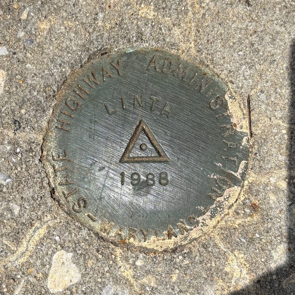
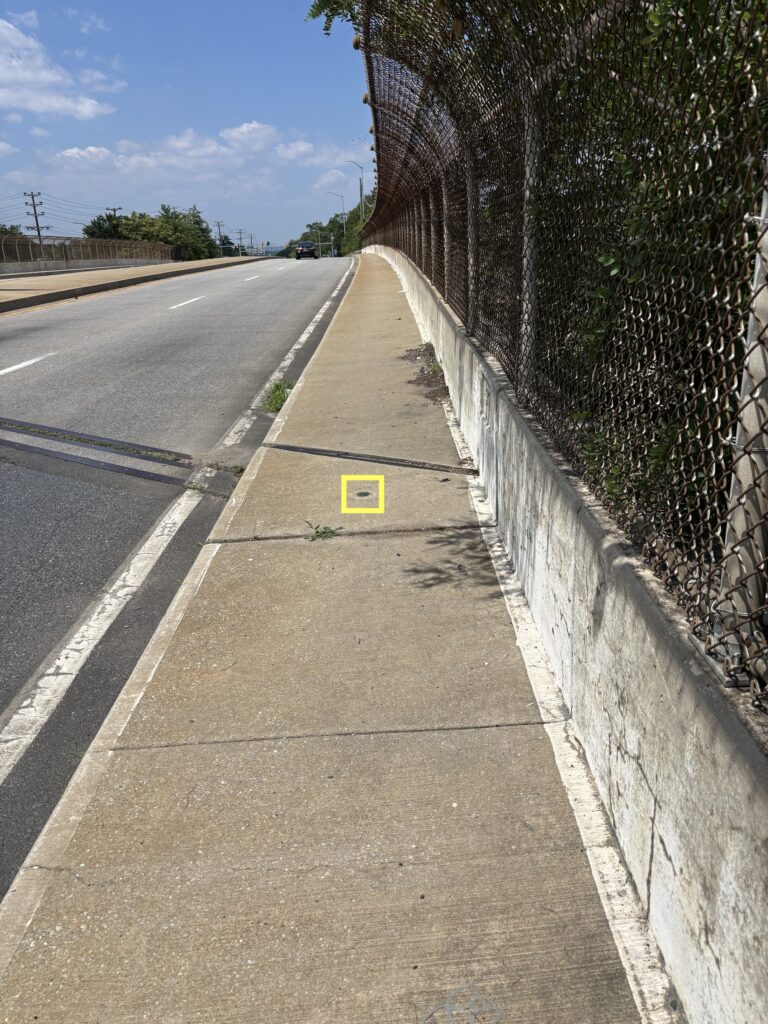
PROGRAM = datasheet95, VERSION = 8.12.5.20
Starting Datasheet Retrieval...
1    National Geodetic Survey, Retrieval Date = JULY  4, 2025 23:12:02 EDT
 JV6581 ***********************************************************************
 JV6581  DESIGNATION -  LINTH
 JV6581  PID         -  JV6581
 JV6581  STATE/COUNTY-  MD/ANNE ARUNDEL
 JV6581  COUNTRY     -  US
 JV6581  USGS QUAD   -  RELAY (2016)
 JV6581
 JV6581                         *CURRENT SURVEY CONTROL
 JV6581  ______________________________________________________________________
 JV6581* NAD 83(1991) POSITION- 39 12 20.28673(N) 076 38 29.25865(W)   NO CHECK
 JV6581* NAVD 88 ORTHO HEIGHT -    54.68  (meters)      179.4   (feet) RESET
 JV6581  ______________________________________________________________________
 JV6581  GEOID HEIGHT    -        -32.750 (meters)                     GEOID18
 JV6581  LAPLACE CORR    -         -5.39  (seconds)                    DEFLEC18
 JV6581  HORZ ORDER      -  THIRD
 JV6581  VERT ORDER      -  THIRD
 JV6581
 JV6581.The horizontal coordinates were established by classical geodetic methods
 JV6581.and adjusted by the National Geodetic Survey in January 1992.
 JV6581
 JV6581.No horizontal observational check was made to the station.
 JV6581
 JV6581.The orthometric height was computed from unverified reset data.
 JV6581
 JV6581.No vertical observational check was made to the station.
 JV6581
 JV6581.Significant digits in the geoid height do not necessarily reflect accuracy.
 JV6581.GEOID18 height accuracy estimate available here.
 JV6581
 JV6581.Click photographs - Photos may exist for this station.
 JV6581
 JV6581.The Laplace correction was computed from DEFLEC18 derived deflections.
 JV6581
 JV6581. The following values were computed from the NAD 83(1991) position.
 JV6581
 JV6581;                    North         East     Units Scale Factor Converg.
 JV6581;SPC MD       -   170,895.162   430,967.744   MT  0.99996638   +0 13 30.1
 JV6581;SPC MD       -   560,678.54  1,413,933.34   sFT  0.99996638   +0 13 30.1
 JV6581;UTM  18      - 4,340,880.031   358,271.437   MT  0.99984733   -1 02 15.9
 JV6581
 JV6581!             -  Elev Factor  x  Scale Factor =   Combined Factor
 JV6581!SPC MD       -   0.99999656  x   0.99996638  =   0.99996294
 JV6581!UTM  18      -   0.99999656  x   0.99984733  =   0.99984389
 JV6581
 JV6581_U.S. NATIONAL GRID SPATIAL ADDRESS: 18SUJ5827140880(NAD 83)
 JV6581
 JV6581                          SUPERSEDED SURVEY CONTROL
 JV6581
 JV6581  NAD 83(1986)-  39 12 20.28357(N)    076 38 29.26809(W) AD(       ) 3
 JV6581  NGVD 29 (11/18/05)   54.92   (m)          180.2    (f) RESET       3
 JV6581  NGVD 29              54.92   (m)          180.2    (f) LEVELING    3
 JV6581
 JV6581.Superseded values are not recommended for survey control.
 JV6581
 JV6581.NGS no longer adjusts projects to the NAD 27 or NGVD 29 datums.
 JV6581.See file dsdata.pdf to determine how the superseded data were derived.
 JV6581
 JV6581_MARKER: DD = SURVEY DISK
 JV6581_SETTING: 38 = SET IN THE ABUTMENT OR PIER OF A LARGE BRIDGE
 JV6581_SP_SET: SIDEWALK ON BRIDGE ABUTMENT
 JV6581_STAMPING: LINTH 1988
 JV6581_MARK LOGO: MDSHA
 JV6581_STABILITY: B = PROBABLY HOLD POSITION/ELEVATION WELL
 JV6581_SATELLITE: THE SITE LOCATION WAS REPORTED AS SUITABLE FOR
 JV6581+SATELLITE: SATELLITE OBSERVATIONS - October 05, 2022
 JV6581
 JV6581  HISTORY     - Date     Condition        Report By
 JV6581  HISTORY     - 1988     MONUMENTED       MDSHA
 JV6581  HISTORY     - 20020217 GOOD             USPSQD
 JV6581  HISTORY     - 20221005 GOOD             WTBALL
 JV6581
 JV6581                          STATION DESCRIPTION
 JV6581
 JV6581'DESCRIBED BY MARYLAND DOT HIGHWAY ADMINISTRATION 1988
 JV6581'THE STATION IS LOCATED ABOUT 9.8 KM (6.10 MI) SOUTH OF THE APPROXIMATE
 JV6581'CENTER OF BALTIMORE, 1.5 KM (0.95 MI) EAST OF LINTHICUM AND IN THE
 JV6581'SOUTH END OF THE EAST SIDEWALK FOR THE OVERPASS BRIDGE WHERE STATE
 JV6581'HIGHWAY 648 CROSSES INTERSTATE HIGHWAY 695.  OWNERSHIP--ROAD
 JV6581'RIGHT-OF-WAY.
 JV6581'NO TO REACH IS NECESSARY.
 JV6581'THE DISK PROJECTS ABOUT 0.3 M (1.0 FT) ABOVE THE BRIDGE DECK.  IT IS
 JV6581'0.8 M (2.6 FT) SOUTH OF THE MOST SOUTHERLY EXPANSION JOINT ON THE
 JV6581'BRIDGE, 5.0 M (16.4 FT) EAST OF THE CENTER OF THE NORTH BOUND LANE OF
 JV6581'STATE HIGHWAY 648, 9.4 M (30.8 FT) NORTH OF THE SOUTH END OF THE EAST
 JV6581'PARAPET WALL AND 18.8 M (61.7 FT) NORTH FROM THE CENTER OF LARGE DROP
 JV6581'INLET.
 JV6581
 JV6581                          STATION RECOVERY (2002)
 JV6581
 JV6581'RECOVERY NOTE BY US POWER SQUADRON 2002 (CRA)
 JV6581'RECOVERED IN GOOD CONDITION.
 JV6581
 JV6581                          STATION RECOVERY (2022)
 JV6581
 JV6581'RECOVERY NOTE BY THE WILSON T BALLARD COMPANY 2022 (NAW)
 JV6581'RECOVERED IN GOOD CONDITION.
Log: Recovered in good condition on Sunday 7/25/2025 at 2:26pm EDT. In spite of the sidewalks, this area is not very walkable, but it’s still possible to reach the mark relatively safely. The GPS coordinates seemed pretty close, and the MDOT locating instructions are still accurate. The disc is flush with the sidewalk and easy to spot. This is the first benchmark disc that I’ve logged since the geocaching.com benchmarking sunset (I have logged a few spires and domes in the meantime). Benchmarking has always been sort of a side game to geocaching for me, but I still find it more interesting than, say, waymarking or Munzee. Maybe I missed my calling to be a surveyor?
There is another nearby mark, JV6578, that I would like to look for during the non-growing season. I walked by it today, but the grass was a little high (and the sun a little too hot) for me to want to go wandering into the field where it is located.