1 National Geodetic Survey, Retrieval Date = NOVEMBER 4, 2025 13:57:32 EST
HV6722 ***********************************************************************
HV6722 DESIGNATION - SOLOMONS ST PETERS EPIS CHURCH
HV6722 PID - HV6722
HV6722 STATE/COUNTY- MD/CALVERT
HV6722 COUNTRY - US
HV6722 USGS QUAD - SOLOMONS ISLAND (2016)
HV6722
HV6722 *CURRENT SURVEY CONTROL
HV6722 ______________________________________________________________________
HV6722* NAD 83(1991) POSITION- 38 19 15.85630(N) 076 27 29.97337(W) ADJUSTED
HV6722 ______________________________________________________________________
HV6722 GEOID HEIGHT - -34.389 (meters) GEOID18
HV6722 LAPLACE CORR - -5.20 (seconds) DEFLEC18
HV6722 HORZ ORDER - THIRD
HV6722
HV6722.The horizontal coordinates were established by classical geodetic methods
HV6722.and adjusted by the National Geodetic Survey in January 1992.
HV6722
HV6722.Significant digits in the geoid height do not necessarily reflect accuracy.
HV6722.GEOID18 height accuracy estimate available here.
HV6722
HV6722.Click photographs - Photos may exist for this station.
HV6722
HV6722.The Laplace correction was computed from DEFLEC18 derived deflections.
HV6722
HV6722. The following values were computed from the NAD 83(1991) position.
HV6722
HV6722; North East Units Scale Factor Converg.
HV6722;SPC MD - 72,782.336 447,367.941 MT 0.99999640 +0 20 23.9
HV6722;SPC MD - 238,786.71 1,467,739.65 sFT 0.99999640 +0 20 23.9
HV6722;UTM 18 - 4,242,445.600 372,519.907 MT 0.99980014 -0 54 15.8
HV6722
HV6722_U.S. NATIONAL GRID SPATIAL ADDRESS: 18SUH7251942445(NAD 83)
HV6722
HV6722 SUPERSEDED SURVEY CONTROL
HV6722
HV6722 NAD 83(1986)- 38 19 15.85571(N) 076 27 29.98788(W) AD( ) 3
HV6722 NAD 27 - 38 19 15.40700(N) 076 27 31.14400(W) AD( ) 3
HV6722
HV6722.Superseded values are not recommended for survey control.
HV6722
HV6722.NGS no longer adjusts projects to the NAD 27 or NGVD 29 datums.
HV6722.See file dsdata.pdf to determine how the superseded data were derived.
HV6722
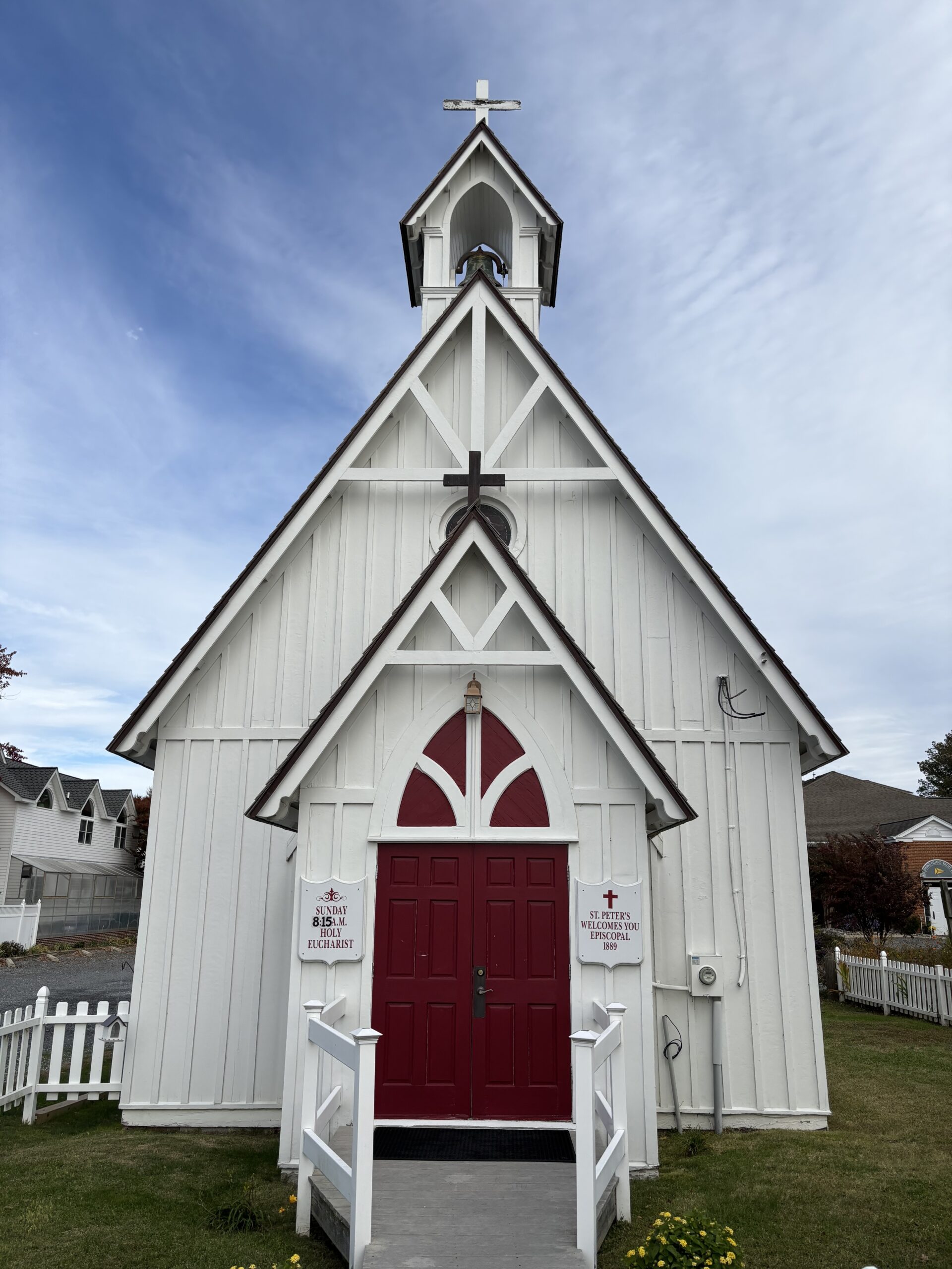
HV6722_MARKER: 91 = CHURCH CROSS
HV6722_SATELLITE: THE SITE LOCATION WAS REPORTED AS SUITABLE FOR
HV6722+SATELLITE: SATELLITE OBSERVATIONS - August 01, 2011
HV6722
HV6722 HISTORY - Date Condition Report By
HV6722 HISTORY - 1943 FIRST OBSERVED CGS
HV6722 HISTORY - 1960 GOOD CGS
HV6722 HISTORY - 20050726 GOOD USPSQD
HV6722 HISTORY - 20060923 GOOD USPSQD
HV6722 HISTORY - 20110801 GOOD GEOCAC
HV6722
HV6722 STATION DESCRIPTION
HV6722
HV6722'DESCRIBED BY COAST AND GEODETIC SURVEY 1943 (BHR)
HV6722'STATION IS ON THE N SHORE OF THE PATUXENT RIVER IN THE TOWN OF
HV6722'SOLOMONS ON SOLOMONS ISLAND, OPPOSITE EVANS PAVILION. THE
HV6722'STATION IS THE CENTER AND TOP OF THE HIGHEST CROSS ON THE
HV6722'ST. PETERS EPISCOPAL CHURCH.
HV6722
HV6722 STATION RECOVERY (1960)
HV6722
HV6722'RECOVERY NOTE BY COAST AND GEODETIC SURVEY 1960 (LFB)
HV6722'STATION RECOVERED. THE PUBLISHED DESCRIPTION IS ADEQUATE.
HV6722
HV6722 STATION RECOVERY (2005)
HV6722
HV6722'RECOVERY NOTE BY US POWER SQUADRON 2005 (BRE)
HV6722'AS DESCRIBED
HV6722
HV6722 STATION RECOVERY (2006)
HV6722
HV6722'RECOVERY NOTE BY US POWER SQUADRON 2006 (JCH)
HV6722'RECOVERED IN GOOD CONDITION.
HV6722
HV6722 STATION RECOVERY (2011)
HV6722
HV6722'RECOVERY NOTE BY GEOCACHING 2011 (DPB)
HV6722'RECOVERED IN GOOD CONDITION.
Log: Recovered in good condition on Tuesday, 11/04/2025 at 1:30pm EST. Description from Wikipedia: “St. Peter’s Chapel is an historic Carpenter Gothic-style Episcopal church building located at 14590 Solomon’s Island Road, South, in Solomons, Calvert County, Maryland. Built in 1889, it features the steep roof, lancet windows and board and batten siding typical of Carpenter Gothic churches. In 1900 it joined with Middleham Chapel to form Middleham and St. Peter’s Episcopal Parish in the Episcopal Diocese of Maryland. St. Peter’s Chapel is still in use today.” The station is the center and top of the highest cross (photo below; top of cupola).
