1 National Geodetic Survey, Retrieval Date = NOVEMBER 4, 2025 13:57:32 EST
HV0364 ***********************************************************************
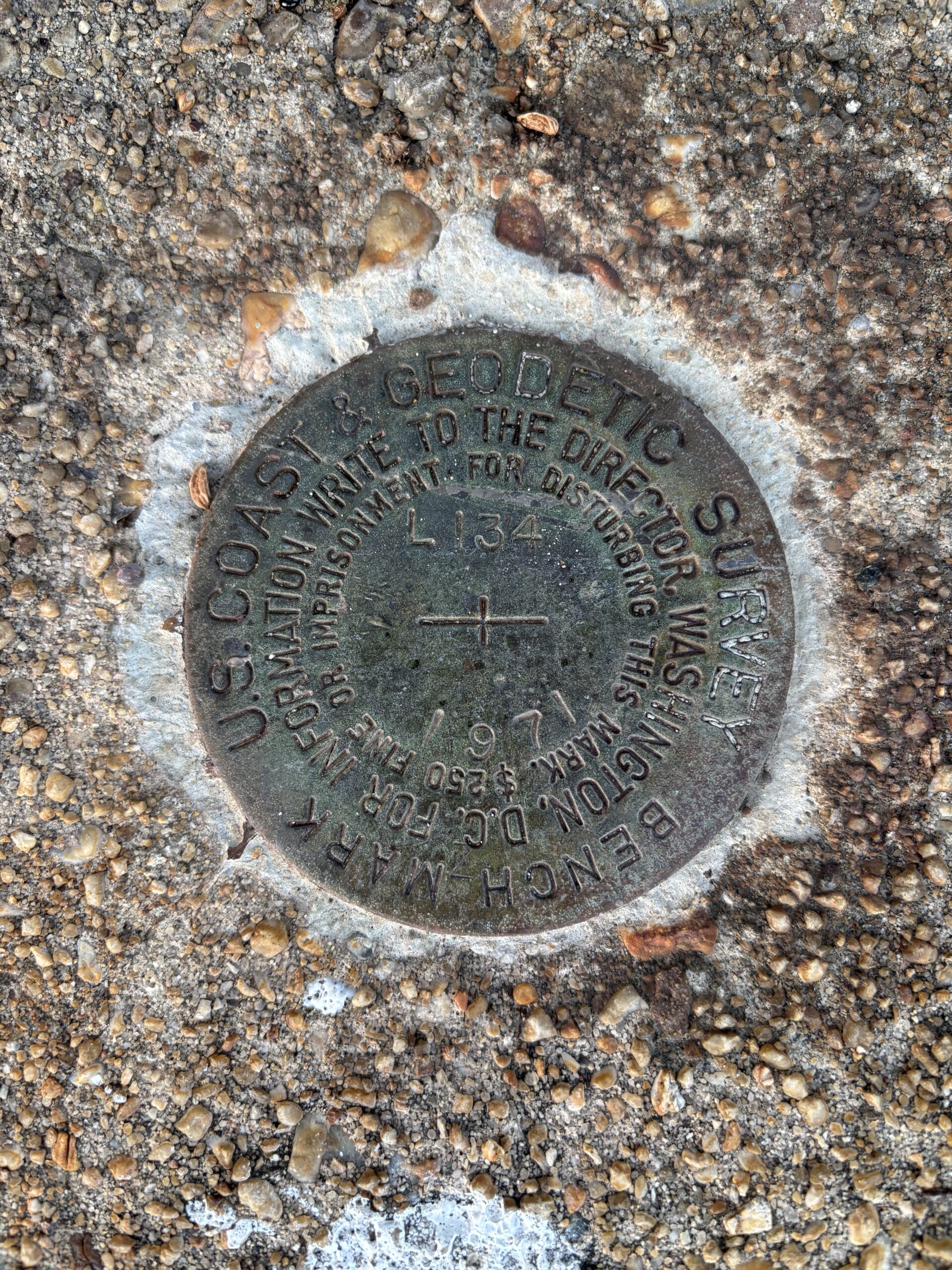
HV0364 DESIGNATION - L 134
HV0364 PID - HV0364
HV0364 STATE/COUNTY- MD/CALVERT
HV0364 COUNTRY - US
HV0364 USGS QUAD - SOLOMONS ISLAND (2016)
HV0364
HV0364 *CURRENT SURVEY CONTROL
HV0364 ______________________________________________________________________
HV0364* NAD 83(1986) POSITION- 38 19 27.54 (N) 076 27 39.96 (W) HD_HELD1
HV0364* NAVD 88 ORTHO HEIGHT - 1.452 (meters) 4.76 (feet) ADJUSTED
HV0364 ______________________________________________________________________
HV0364 GEOID HEIGHT - -34.377 (meters) GEOID18
HV0364 DYNAMIC HEIGHT - 1.451 (meters) 4.76 (feet) COMP
HV0364 MODELED GRAVITY - 980,021.1 (mgal) NAVD 88
HV0364
HV0364 VERT ORDER - FIRST CLASS II
HV0364
HV0364.The horizontal coordinates were determined by differentially corrected
HV0364.hand held GPS observations or other comparable positioning techniques
HV0364.and have an estimated accuracy of +/- 3 meters.
HV0364
HV0364.The orthometric height was determined by differential leveling and
HV0364.adjusted by the NATIONAL GEODETIC SURVEY
HV0364.in June 1991.
HV0364
HV0364.Significant digits in the geoid height do not necessarily reflect accuracy.
HV0364.GEOID18 height accuracy estimate available here.
HV0364
HV0364.Click photographs - Photos may exist for this station.
HV0364
HV0364.The dynamic height is computed by dividing the NAVD 88
HV0364.geopotential number by the normal gravity value computed on the
HV0364.Geodetic Reference System of 1980 (GRS 80) ellipsoid at 45
HV0364.degrees latitude (g = 980.6199 gals.).
HV0364
HV0364.The modeled gravity was interpolated from observed gravity values.
HV0364
HV0364; North East Units Estimated Accuracy
HV0364;SPC MD - 73,141.1 447,123.2 MT (+/- 3 meters HH1 GPS)
HV0364
HV0364_U.S. NATIONAL GRID SPATIAL ADDRESS: 18SUH7228342809(NAD 83)
HV0364
HV0364 SUPERSEDED SURVEY CONTROL
HV0364
HV0364 NGVD 29 (11/26/84) 1.696 (m) 5.56 (f) ADJUSTED 1 2
HV0364
HV0364.Superseded values are not recommended for survey control.
HV0364
HV0364.NGS no longer adjusts projects to the NAD 27 or NGVD 29 datums.
HV0364.See file dsdata.pdf to determine how the superseded data were derived.
HV0364
HV0364_MARKER: DB = BENCH MARK DISK
HV0364_SETTING: 36 = SET IN A MASSIVE STRUCTURE
HV0364_SP_SET: BRIDGE
HV0364_STAMPING: L 134 1971
HV0364_MARK LOGO: CGS
HV0364_STABILITY: B = PROBABLY HOLD POSITION/ELEVATION WELL
HV0364_SATELLITE: THE SITE LOCATION WAS REPORTED AS SUITABLE FOR
HV0364+SATELLITE: SATELLITE OBSERVATIONS - October 23, 2023
HV0364
HV0364 HISTORY - Date Condition Report By
HV0364 HISTORY - 1971 MONUMENTED NGS
HV0364 HISTORY - 19950812 GOOD USPSQD
HV0364 HISTORY - 20020131 GOOD USPSQD
HV0364 HISTORY - 20110731 GOOD GEOCAC
HV0364 HISTORY - 20130625 GOOD GEOMET
HV0364 HISTORY - 20220731 GOOD WTBALL
HV0364 HISTORY - 20231023 GOOD USPSQD
HV0364
HV0364 STATION DESCRIPTION
HV0364
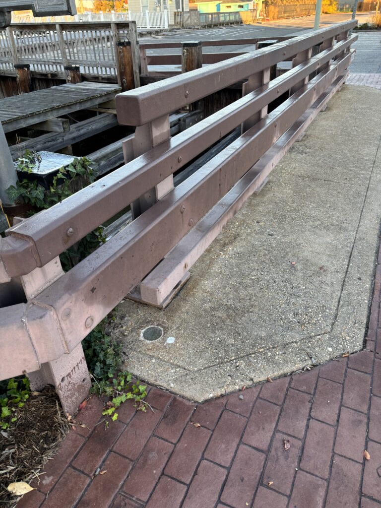
HV0364'DESCRIBED BY NATIONAL GEODETIC SURVEY 1971
HV0364'AT SOLOMONS.
HV0364'AT SOLOMONS, ABOUT 0.1 MILE NORTH ALONG STATE HIGHWAY 2 AND 4
HV0364'FROM THE METHODIST CHURCH, 42 YARDS NORTHWEST OF AND ACROSS THE
HV0364'HIGHWAY FROM THE NORTHWEST CORNER OF A BUILDING WHICH HOUSES
HV0364'THE POST OFFICE, SET ON THE TOP OF THE SOUTH END OF THE CONCRETE
HV0364'BASE FOR THE WEST STEEL AND CONCRETE GUARD RAIL BASE FOR A
HV0364'25-FOOT BRIDGE OVER A SMALL INLET, 26.3 FET WEST OF THE CENTER
HV0364'LINE OF THE HIGHWAY, 1 FOOT NORTHEAST OF THE SOUTH END OF THE
HV0364'WEST STEEL GUARDRAIL OF THE BRIDGE AND 8 INCHES ABOVE THE LEVEL
HV0364'OF THE BRIDGE FLOOR.
HV0364
HV0364 STATION RECOVERY (1995)
HV0364
HV0364'RECOVERY NOTE BY US POWER SQUADRON 1995
HV0364'RECOVERED IN GOOD CONDITION.
HV0364
HV0364 STATION RECOVERY (2002)
HV0364
HV0364'RECOVERY NOTE BY US POWER SQUADRON 2002 (SAL)
HV0364'RECOVERED IN GOOD CONDITION.
HV0364
HV0364 STATION RECOVERY (2011)
HV0364
HV0364'RECOVERY NOTE BY GEOCACHING 2011 (DPB)
HV0364'2 FEET EAST OF SOLOMON'S ISLAND HISTORICAL SIGNPOST.
HV0364
HV0364 STATION RECOVERY (2013)
HV0364
HV0364'RECOVERY NOTE BY GEOMETRICS GPS INCORPORATED 2013 (DWB)
HV0364'RECOVERED AS DESCRIBED.
HV0364
HV0364 STATION RECOVERY (2022)
HV0364
HV0364'RECOVERY NOTE BY THE WILSON T BALLARD COMPANY 2022 (JMB)
HV0364'RECOVERED IN GOOD CONDITION.
HV0364
HV0364 STATION RECOVERY (2023)
HV0364
HV0364'RECOVERY NOTE BY US POWER SQUADRON 2023 (DMM)
HV0364'RECOVERED IN GOOD CONDITION.
Log: Recovered in good condition on Wednesday, 11/05/2025 at 6:59am EST. Interesting area right near the narrow channel that separates Solomon’s Island from the mainland. The benchmark is fairly easy to spot from the sidewalk.