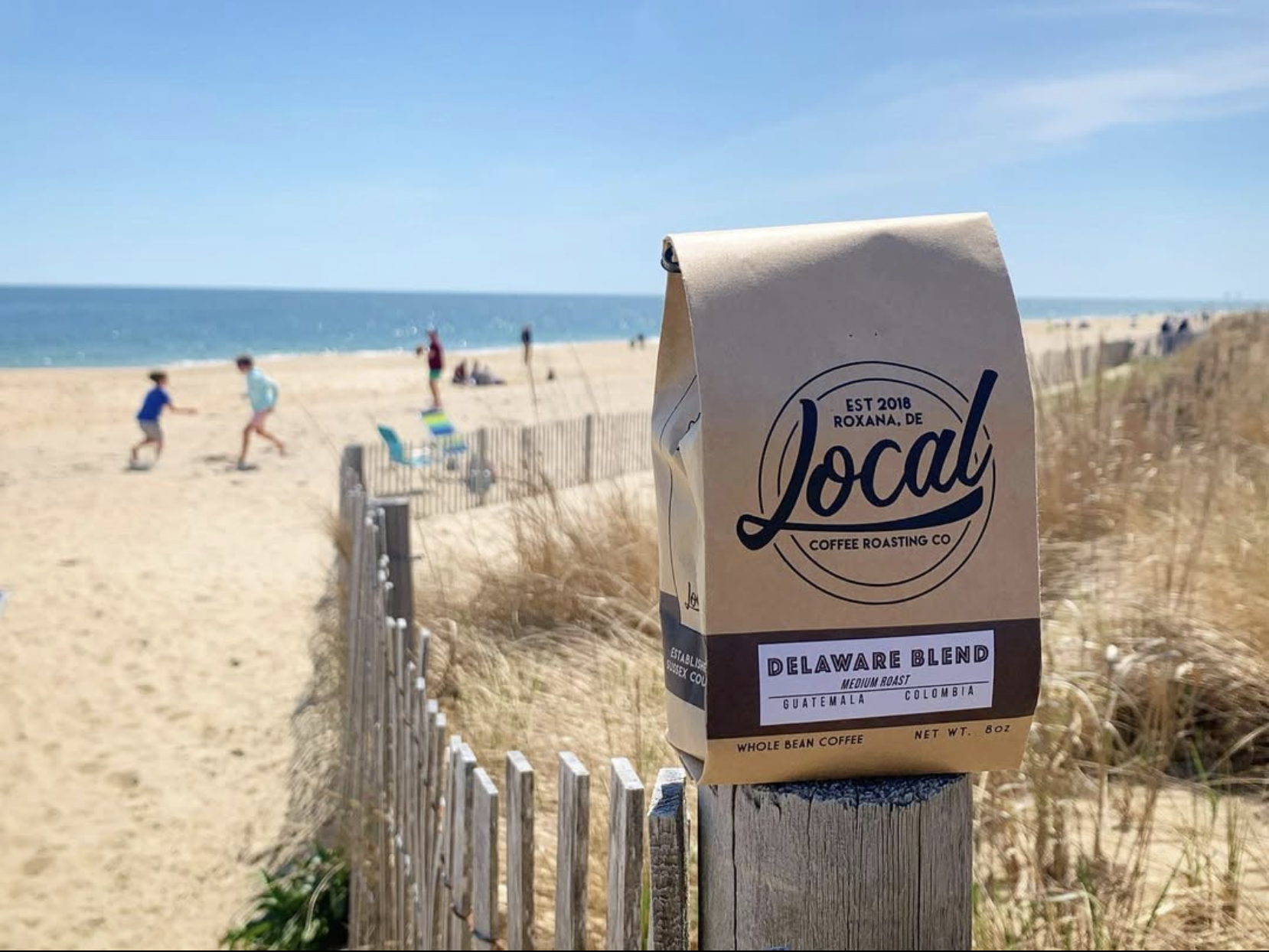
Author: lpaulriddle

  • November 8 Post

    November 8 Post

    Lately, when I remember, I’ve taken to reading posts that I wrote here on the same month and day in previous years. WordPress makes it easy to search for all posts on a given month and day (via the monthnum and day query string parameters) and from there, I whipped up a quick PHP script to generate the appropriate search string based on the current date. It’s interesting seeing what I wrote on a given date, say, 15 years ago (and incidentally, we’re only 10 days away from the 20th anniversary of my first post). At this point, it seems like I have written posts on most days of the year, but there are a few dates with no posts, and until now, November 8 was one of them.

    I had initially been thinking about running the BWI loop this morning, but I decided I didn’t want to deal with all of the people on the trail on a mild day, so I ran on familiar roads around home, and ended up going 13.1 miles. It was my third half-marathon of the season, and I averaged 10:48/mile. I am dealing with some extensor tendonitis in my left foot, but running doesn’t really affect it much (walking and climbing seem to be the main culprits) and other than that, I have no major physical issues right now. I had plenty of energy, and finished stronger than last time I ran this distance (Oct 19) so it seems like I am getting back in shape for longer runs.

    It is getting to be time to winterize the pool. The pool has lost a lot of water the past couple of winters, making me suspect a leak, but it never seems to lose water during the summer. This afternoon, I went to check the Chlorine and water levels, and was surprised to find that the water had already dropped to about 3/4″ below the tile line. This fall has been dry and windy, so It could be due to evaporation, but it’s never dropped that much so early in the off-season. The silver lining is that it saves me work, as I won’t need to pump water out of the pool to winterize the skimmers. However, I don’t want the water level dropping too low to support the cover if we get snow this winter, so, I’m going to have to keep an eye on it, see how much it drops, and add water if needed.

    Last topic for the day is blood pressure. I have a family history of high blood pressure, and I keep mine in check with all of my exercising, but I’ve still had to take a low dose of BP meds since about age 35. The best way to stay on top of BP is to monitor it regularly at home, but I have always had kind of a phobia about taking my BP. Even thinking about it would cause my heart to start racing, and as a result, my BP would shoot up and I could never get an accurate reading. Last month, a BP scare at the doctor’s office prompted me to buy a new monitor, a Withings BPM Vision. It connects to the wifi and records all of my readings in the Withings app (and Apple Health). This has been great, because it turns out that my phobia isn’t about the actual process of taking my BP, but rather viewing the results. With the BPM Vision, I can keep the machine covered while I take my BP every day, and then wait until much later and review all of the results in the app. This seems to have done the trick: for the most part, I am now much more relaxed when I take readings, and by viewing (say) a week’s worth of readings at a time, I get a better overall picture of my BP rather than worrying about individual readings. So far, so good.

  • Bugeye Rwanda

    Bugeye Rwanda

    • Beans: Rwanda (single origin, pre-ground)
      • Roaster: Bugeye Coffee Roasters (Solomons, MD)
      • Origin: Rwanda (Ruli Mountain)
      • Roast level: Full City (Medium/Dark)
      • Roast date: 10/1/2025 (batch 254)
      • Purchase date: 10/23/2025 from Bugeye stall at Sunfest, Ocean City, MD
        First cup: Around 11/1/2025; Last cup:
      • Tasting notes: Black cherry, dark chocolate, red currant
    • V60 (1 cup):
      • 20g to 21g coffee / 300g water (1:14-1:15)
      • Water at 95°C
      • Single Cup V60 Pourover with 60g bloom and 60g pulses – Finishes around 02:50
    • AeroPress:

    This is the first time I have ever tried coffee from Rwanda, either single origin, or as part of a blend, so I was curious to see how it tasted. For some reason, this is only sold pre-ground, which doesn’t make sense to me, as it seems like people who buy single-origin coffees are going to be more likely to want to grind the beans themselves. Case in point: had I realized it was pre-ground at the time I bought it, I likely would have taken a pass. However, the grind seems pretty consistent, and worked well for both pour-over and AeroPress, so I have no regrets. It looks like a middle-of-the-road grind: not too fine, not too coarse. As of this writing, I’ve brewed it a couple of times with the V60 at home, and a couple of times with the AeroPress on a recent trip. The mouthfeel is smooth and buttery, and the taste is roasty and full-bodied — pretty much how I like dark roasts to taste. I think the V60 cups were slightly superior, but it would be interesting to try AeroPress under more controlled circumstances. Not sure if I’ll get around to that, though.

  • HV6711 ~ SOLOMONS ISLAND ME CHURCH

    HV6711 ~ SOLOMONS ISLAND ME CHURCH

    1    National Geodetic Survey, Retrieval Date = NOVEMBER  4, 2025 13:57:32 EST
    HV6711 ***********************************************************************
    HV6711 DESIGNATION - SOLOMONS ISLAND ME CHURCH
    HV6711 PID - HV6711
    HV6711 STATE/COUNTY- MD/CALVERT
    HV6711 COUNTRY - US
    HV6711 USGS QUAD - SOLOMONS ISLAND (2016)
    HV6711
    HV6711 *CURRENT SURVEY CONTROL
    HV6711 ______________________________________________________________________
    HV6711* NAD 83(1991) POSITION- 38 19 23.52443(N) 076 27 36.26676(W) ADJUSTED
    HV6711 ______________________________________________________________________
    HV6711 GEOID HEIGHT - -34.381 (meters) GEOID18
    HV6711 LAPLACE CORR - -5.15 (seconds) DEFLEC18
    HV6711 HORZ ORDER - THIRD
    HV6711
    HV6711.The horizontal coordinates were established by classical geodetic methods
    HV6711.and adjusted by the National Geodetic Survey in January 1992.
    HV6711
    HV6711.Significant digits in the geoid height do not necessarily reflect accuracy.
    HV6711.GEOID18 height accuracy estimate available here.
    HV6711
    HV6711.Click photographs - Photos may exist for this station.
    HV6711
    HV6711.The Laplace correction was computed from DEFLEC18 derived deflections.
    HV6711
    HV6711. The following values were computed from the NAD 83(1991) position.
    HV6711
    HV6711; North East Units Scale Factor Converg.
    HV6711;SPC MD - 73,017.865 447,213.672 MT 0.99999604 +0 20 20.0
    HV6711;SPC MD - 239,559.45 1,467,233.52 sFT 0.99999604 +0 20 20.0
    HV6711;UTM 18 - 4,242,684.377 372,370.818 MT 0.99980061 -0 54 19.8
    HV6711
    HV6711_U.S. NATIONAL GRID SPATIAL ADDRESS: 18SUH7237042684(NAD 83)
    HV6711
    HV6711 SUPERSEDED SURVEY CONTROL
    HV6711
    HV6711 NAD 83(1986)- 38 19 23.52424(N) 076 27 36.28172(W) AD( ) 3
    HV6711 NAD 27 - 38 19 23.07600(N) 076 27 37.44000(W) AD( ) 3
    HV6711 USSD - 38 19 23.44900(N) 076 27 37.20100(W) AD( ) 3
    HV6711
    HV6711.Superseded values are not recommended for survey control.
    HV6711
    HV6711.NGS no longer adjusts projects to the NAD 27 or NGVD 29 datums.
    HV6711.See file dsdata.pdf to determine how the superseded data were derived.
    HV6711
    HV6711_SATELLITE: THE SITE LOCATION WAS REPORTED AS SUITABLE FOR
    HV6711+SATELLITE: SATELLITE OBSERVATIONS - July 31, 2011
    HV6711
    HV6711 HISTORY - Date Condition Report By
    HV6711 HISTORY - 1907 FIRST OBSERVED CGS
    HV6711 HISTORY - 1960 GOOD CGS
    HV6711 HISTORY - 20050726 GOOD USPSQD
    HV6711 HISTORY - 20060923 GOOD USPSQD
    HV6711 HISTORY - 20110731 GOOD GEOCAC
    HV6711
    HV6711 STATION DESCRIPTION
    HV6711
    HV6711'DESCRIBED BY COAST AND GEODETIC SURVEY 1907 (OWF)
    HV6711'STATION IS ON THE NORTHEASTERN SHORE OF PATUXENT RIVER, ON UPPER
    HV6711'END OF SOLOMONS ISLAND, ON PATUXENT AVENUE, NEAR BEGINNING OF
    HV6711'CAUSEWAY TO MAINLAND. STATION IS TIP OF PYRAMIDAL TOWER ON
    HV6711'METHODIST CHURCH.
    HV6711
    HV6711 STATION RECOVERY (1960)
    HV6711
    HV6711'RECOVERY NOTE BY COAST AND GEODETIC SURVEY 1960 (LFB)
    HV6711'STATION RECOVERED. THE PUBLISHED DESCRIPTION IS ADEQUATE.
    HV6711
    HV6711 STATION RECOVERY (2005)
    HV6711
    HV6711'RECOVERY NOTE BY US POWER SQUADRON 2005 (BRE)
    HV6711'AS DESCRIBED
    HV6711
    HV6711 STATION RECOVERY (2006)
    HV6711
    HV6711'RECOVERY NOTE BY US POWER SQUADRON 2006 (JCH)
    HV6711'RECOVERED IN GOOD CONDITION.
    HV6711
    HV6711 STATION RECOVERY (2011)
    HV6711
    HV6711'RECOVERY NOTE BY GEOCACHING 2011 (DPB)
    HV6711'RECOVERED IN GOOD CONDITION.

    Log: Recovered on Wednesday, 11/5/2025 at 7:07am. Based on what I found online, it seems that the Methodist Church, which was founded around 1866, closed its doors in 2021. It now operates as the Solomons Mission Center, a food pantry. The building itself seems to be in pretty good shape. In the photo, there is a bird perched on top of the station.

  • HV0364 ~ L 134

    HV0364 ~ L 134

    1    National Geodetic Survey, Retrieval Date = NOVEMBER  4, 2025 13:57:32 EST
    HV0364 ***********************************************************************
    HV0364 DESIGNATION - L 134
    HV0364 PID - HV0364
    HV0364 STATE/COUNTY- MD/CALVERT
    HV0364 COUNTRY - US
    HV0364 USGS QUAD - SOLOMONS ISLAND (2016)
    HV0364
    HV0364 *CURRENT SURVEY CONTROL
    HV0364 ______________________________________________________________________
    HV0364* NAD 83(1986) POSITION- 38 19 27.54 (N) 076 27 39.96 (W) HD_HELD1
    HV0364* NAVD 88 ORTHO HEIGHT - 1.452 (meters) 4.76 (feet) ADJUSTED
    HV0364 ______________________________________________________________________
    HV0364 GEOID HEIGHT - -34.377 (meters) GEOID18
    HV0364 DYNAMIC HEIGHT - 1.451 (meters) 4.76 (feet) COMP
    HV0364 MODELED GRAVITY - 980,021.1 (mgal) NAVD 88
    HV0364
    HV0364 VERT ORDER - FIRST CLASS II
    HV0364
    HV0364.The horizontal coordinates were determined by differentially corrected
    HV0364.hand held GPS observations or other comparable positioning techniques
    HV0364.and have an estimated accuracy of +/- 3 meters.
    HV0364
    HV0364.The orthometric height was determined by differential leveling and
    HV0364.adjusted by the NATIONAL GEODETIC SURVEY
    HV0364.in June 1991.
    HV0364
    HV0364.Significant digits in the geoid height do not necessarily reflect accuracy.
    HV0364.GEOID18 height accuracy estimate available here.
    HV0364
    HV0364.Click photographs - Photos may exist for this station.
    HV0364
    HV0364.The dynamic height is computed by dividing the NAVD 88
    HV0364.geopotential number by the normal gravity value computed on the
    HV0364.Geodetic Reference System of 1980 (GRS 80) ellipsoid at 45
    HV0364.degrees latitude (g = 980.6199 gals.).
    HV0364
    HV0364.The modeled gravity was interpolated from observed gravity values.
    HV0364
    HV0364; North East Units Estimated Accuracy
    HV0364;SPC MD - 73,141.1 447,123.2 MT (+/- 3 meters HH1 GPS)
    HV0364
    HV0364_U.S. NATIONAL GRID SPATIAL ADDRESS: 18SUH7228342809(NAD 83)
    HV0364
    HV0364 SUPERSEDED SURVEY CONTROL
    HV0364
    HV0364 NGVD 29 (11/26/84) 1.696 (m) 5.56 (f) ADJUSTED 1 2
    HV0364
    HV0364.Superseded values are not recommended for survey control.
    HV0364
    HV0364.NGS no longer adjusts projects to the NAD 27 or NGVD 29 datums.
    HV0364.See file dsdata.pdf to determine how the superseded data were derived.
    HV0364
    HV0364_MARKER: DB = BENCH MARK DISK
    HV0364_SETTING: 36 = SET IN A MASSIVE STRUCTURE
    HV0364_SP_SET: BRIDGE
    HV0364_STAMPING: L 134 1971
    HV0364_MARK LOGO: CGS
    HV0364_STABILITY: B = PROBABLY HOLD POSITION/ELEVATION WELL
    HV0364_SATELLITE: THE SITE LOCATION WAS REPORTED AS SUITABLE FOR
    HV0364+SATELLITE: SATELLITE OBSERVATIONS - October 23, 2023
    HV0364
    HV0364 HISTORY - Date Condition Report By
    HV0364 HISTORY - 1971 MONUMENTED NGS
    HV0364 HISTORY - 19950812 GOOD USPSQD
    HV0364 HISTORY - 20020131 GOOD USPSQD
    HV0364 HISTORY - 20110731 GOOD GEOCAC
    HV0364 HISTORY - 20130625 GOOD GEOMET
    HV0364 HISTORY - 20220731 GOOD WTBALL
    HV0364 HISTORY - 20231023 GOOD USPSQD
    HV0364
    HV0364 STATION DESCRIPTION
    HV0364
    HV0364'DESCRIBED BY NATIONAL GEODETIC SURVEY 1971
    HV0364'AT SOLOMONS.
    HV0364'AT SOLOMONS, ABOUT 0.1 MILE NORTH ALONG STATE HIGHWAY 2 AND 4
    HV0364'FROM THE METHODIST CHURCH, 42 YARDS NORTHWEST OF AND ACROSS THE
    HV0364'HIGHWAY FROM THE NORTHWEST CORNER OF A BUILDING WHICH HOUSES
    HV0364'THE POST OFFICE, SET ON THE TOP OF THE SOUTH END OF THE CONCRETE
    HV0364'BASE FOR THE WEST STEEL AND CONCRETE GUARD RAIL BASE FOR A
    HV0364'25-FOOT BRIDGE OVER A SMALL INLET, 26.3 FET WEST OF THE CENTER
    HV0364'LINE OF THE HIGHWAY, 1 FOOT NORTHEAST OF THE SOUTH END OF THE
    HV0364'WEST STEEL GUARDRAIL OF THE BRIDGE AND 8 INCHES ABOVE THE LEVEL
    HV0364'OF THE BRIDGE FLOOR.
    HV0364
    HV0364 STATION RECOVERY (1995)
    HV0364
    HV0364'RECOVERY NOTE BY US POWER SQUADRON 1995
    HV0364'RECOVERED IN GOOD CONDITION.
    HV0364
    HV0364 STATION RECOVERY (2002)
    HV0364
    HV0364'RECOVERY NOTE BY US POWER SQUADRON 2002 (SAL)
    HV0364'RECOVERED IN GOOD CONDITION.
    HV0364
    HV0364 STATION RECOVERY (2011)
    HV0364
    HV0364'RECOVERY NOTE BY GEOCACHING 2011 (DPB)
    HV0364'2 FEET EAST OF SOLOMON'S ISLAND HISTORICAL SIGNPOST.
    HV0364
    HV0364 STATION RECOVERY (2013)
    HV0364
    HV0364'RECOVERY NOTE BY GEOMETRICS GPS INCORPORATED 2013 (DWB)
    HV0364'RECOVERED AS DESCRIBED.
    HV0364
    HV0364 STATION RECOVERY (2022)
    HV0364
    HV0364'RECOVERY NOTE BY THE WILSON T BALLARD COMPANY 2022 (JMB)
    HV0364'RECOVERED IN GOOD CONDITION.
    HV0364
    HV0364 STATION RECOVERY (2023)
    HV0364
    HV0364'RECOVERY NOTE BY US POWER SQUADRON 2023 (DMM)
    HV0364'RECOVERED IN GOOD CONDITION.

    Log: Recovered in good condition on Wednesday, 11/05/2025 at 6:59am EST. Interesting area right near the narrow channel that separates Solomon’s Island from the mainland. The benchmark is fairly easy to spot from the sidewalk.

  • AJ8036 ~ 857 7330 E TIDAL

    AJ8036 ~ 857 7330 E TIDAL

    1    National Geodetic Survey, Retrieval Date = NOVEMBER  4, 2025 13:57:32 EST
    AJ8036 ***********************************************************************
    AJ8036 FBN - This is a Federal Base Network Control Station.
    AJ8036 TIDAL BM - This is a Tidal Bench Mark.
    AJ8036 DESIGNATION - 857 7330 E TIDAL
    AJ8036 PID - AJ8036
    AJ8036 STATE/COUNTY- MD/CALVERT
    AJ8036 COUNTRY - US
    AJ8036 USGS QUAD - SOLOMONS ISLAND (2016)
    AJ8036
    AJ8036 *CURRENT SURVEY CONTROL
    AJ8036 ______________________________________________________________________
    AJ8036* NAD 83(2011) POSITION- 38 19 10.23204(N) 076 27 11.46590(W) ADJUSTED
    AJ8036* NAD 83(2011) ELLIP HT- -31.350 (meters) (06/27/12) ADJUSTED
    AJ8036* NAD 83(2011) EPOCH - 2010.00
    AJ8036* NAVD 88 ORTHO HEIGHT - 3.0 (meters) 10. (feet) GPS OBS
    AJ8036 ______________________________________________________________________
    AJ8036 NAVD 88 orthometric height was determined with geoid model GEOID99
    AJ8036 GEOID HEIGHT - -34.334 (meters) GEOID99
    AJ8036 GEOID HEIGHT - -34.406 (meters) GEOID18
    AJ8036 NAD 83(2011) X - 1,173,656.641 (meters) COMP
    AJ8036 NAD 83(2011) Y - -4,871,094.637 (meters) COMP
    AJ8036 NAD 83(2011) Z - 3,933,310.565 (meters) COMP
    AJ8036 LAPLACE CORR - -5.26 (seconds) DEFLEC18
    AJ8036
    AJ8036 Network accuracy estimates per FGDC Geospatial Positioning Accuracy
    AJ8036 Standards:
    AJ8036 FGDC (95% conf, cm) Standard deviation (cm) CorrNE
    AJ8036 Horiz Ellip SD_N SD_E SD_h (unitless)
    AJ8036 -------------------------------------------------------------------
    AJ8036 NETWORK 0.92 1.92 0.40 0.35 0.98 0.02401171
    AJ8036 -------------------------------------------------------------------
    AJ8036 Click here for local accuracies and other accuracy information.
    AJ8036
    AJ8036.This is a reference station for the SOLOMONS ISLAND
    AJ8036.National Continuously Operating Reference Station (SOL1).
    AJ8036
    AJ8036.The horizontal coordinates were established by GPS observations
    AJ8036.and adjusted by the National Geodetic Survey in June 2012.
    AJ8036
    AJ8036.NAD 83(2011) refers to NAD 83 coordinates where the reference frame has
    AJ8036.been affixed to the stable North American tectonic plate. See
    AJ8036.NA2011 for more information.
    AJ8036
    AJ8036.The horizontal coordinates are valid at the epoch date displayed above
    AJ8036.which is a decimal equivalence of Year/Month/Day.
    AJ8036
    AJ8036.The orthometric height was determined by GPS observations and a
    AJ8036.high-resolution geoid model.
    AJ8036
    AJ8036.Significant digits in the geoid height do not necessarily reflect accuracy.
    AJ8036.GEOID18 height accuracy estimate available here.
    AJ8036
    AJ8036.This Tidal Bench Mark is designated as VM 455
    AJ8036.by the CENTER FOR OPERATIONAL OCEANOGRAPHIC PRODUCTS AND SERVICES.
    AJ8036
    AJ8036.Click photographs - Photos may exist for this station.
    AJ8036
    AJ8036
    AJ8036.The X, Y, and Z were computed from the position and the ellipsoidal ht.
    AJ8036
    AJ8036.The Laplace correction was computed from DEFLEC18 derived deflections.
    AJ8036
    AJ8036.The ellipsoidal height was determined by GPS observations
    AJ8036.and is referenced to NAD 83.
    AJ8036
    AJ8036. The following values were computed from the NAD 83(2011) position.
    AJ8036
    AJ8036; North East Units Scale Factor Converg.
    AJ8036;SPC MD - 72,611.601 447,818.538 MT 0.99999666 +0 20 35.5
    AJ8036;SPC MD - 238,226.56 1,469,217.99 sFT 0.99999666 +0 20 35.5
    AJ8036;UTM 18 - 4,242,265.156 372,966.601 MT 0.99979874 -0 54 04.2
    AJ8036
    AJ8036! - Elev Factor x Scale Factor = Combined Factor
    AJ8036!SPC MD - 1.00000492 x 0.99999666 = 1.00000158
    AJ8036!UTM 18 - 1.00000492 x 0.99979874 = 0.99980366
    AJ8036
    AJ8036_U.S. NATIONAL GRID SPATIAL ADDRESS: 18SUH7296642265(NAD 83)
    AJ8036
    AJ8036|---------------------------------------------------------------------|
    AJ8036| PID Reference Object Distance Geod. Az |
    AJ8036| dddmmss.s |
    AJ8036| AI3287 SOLOMONS ISLAND CORS ARP 94.159 METERS 22059 |
    AJ8036|---------------------------------------------------------------------|
    AJ8036
    AJ8036 SUPERSEDED SURVEY CONTROL
    AJ8036
    AJ8036 NAD 83(2007)- 38 19 10.23223(N) 076 27 11.46657(W) AD(2002.00) 0
    AJ8036 ELLIP H (02/10/07) -31.329 (m) GP(2002.00)
    AJ8036 NAD 83(1991)- 38 19 10.23175(N) 076 27 11.46708(W) AD( ) A
    AJ8036 ELLIP H (02/12/02) -31.324 (m) GP( ) 4 1
    AJ8036
    AJ8036.Superseded values are not recommended for survey control.
    AJ8036
    AJ8036.NGS no longer adjusts projects to the NAD 27 or NGVD 29 datums.
    AJ8036.See file dsdata.pdf to determine how the superseded data were derived.
    AJ8036
    AJ8036_MARKER: DJ = TIDAL STATION DISK
    AJ8036_SETTING: 47 = GALVANIZED STEEL PIPE W/O SLEEVE (10 FT.+)
    AJ8036_STAMPING: 7330 E 1980
    AJ8036_MARK LOGO: NOS
    AJ8036_PROJECTION: RECESSED 3 CENTIMETERS
    AJ8036_MAGNETIC: N = NO MAGNETIC MATERIAL
    AJ8036_STABILITY: B = PROBABLY HOLD POSITION/ELEVATION WELL
    AJ8036_SATELLITE: THE SITE LOCATION WAS REPORTED AS SUITABLE FOR
    AJ8036+SATELLITE: SATELLITE OBSERVATIONS - May 29, 2023
    AJ8036_ROD/PIPE-DEPTH: 12 meters
    AJ8036
    AJ8036 HISTORY - Date Condition Report By
    AJ8036 HISTORY - 1980 MONUMENTED NOS
    AJ8036 HISTORY - 20000216 GOOD NGS
    AJ8036 HISTORY - 20230529 GOOD MDSHA
    AJ8036
    AJ8036 STATION DESCRIPTION
    AJ8036
    AJ8036'DESCRIBED BY NATIONAL GEODETIC SURVEY 2000 (MLM)
    AJ8036'THE STATION IS LOCATED IN SOLOMONS ON THE SOUTHEAST SIDE OF THE
    AJ8036'ENTRANCE DRIVE OF THE SOLOMONS MARINA ON CHARLES STREET AND LOCATED
    AJ8036'JUST SOUTH OF THE JUNCTION OF CHARLES AND WILLIAMS STREET.
    AJ8036'OWNERSHIP--CITY OF SOLOMONS ISLAND. TO REACH THE STATION FROM THE
    AJ8036'JUNCTION OF STATE HIGHWAYS 2 AND 4 LOCATED AT THE NORTHEAST END OF THE
    AJ8036'HIGHWAY 4 BRIDGE OVER THE PATUXENT RIVER AND AT THE VISITOR CENTER
    AJ8036'(REST AREA) ON THE NORTH SIDE OF SOLOMONS, GO SOUTH ON HIGHWAY 2 FOR
    AJ8036'1.53 KM (0.95 MI) TO THE JUNCTION OF CHARLES AND PATUXENT STREETS IN
    AJ8036'SOLOMONS, BEAR LEFT, ON CHARLES STREET, SOUTHEASTERLY FOR 0.4 KM (0.25
    AJ8036'MI) TO THE ENTRANCE OF THE SOLOMONS MARINA AND THE STATION ON THE
    AJ8036'SOUTHEAST SIDE OF THE ENTRANCE DRIVE. THE STATION IS AN NOS TIDAL
    AJ8036'DISK CRIMPED TO THE TOP OF A GALVANIZED STEEL ROD, ENCASED IN A 10 CM
    AJ8036'PVC PIPE ABOUT 8 CM BELOW THE GROUND, LOCATED 6.40 M (21.00 FT)
    AJ8036'NORTHEAST OF THE CENTER OF CHARLES STREET, 2.02 M (6.63 FT) NORTH OF
    AJ8036'THE WEST CORNER POST OF A CHAIN LINK FENCE, 1.83 M (6.00 FT) SOUTHWEST
    AJ8036'OF THE SOUTHWEST WOOD POST SUPORTING A SIGN (SOLOMONS MARINA) , 1.56 M
    AJ8036'(5.12 FT) WEST-SOUTHWEST OF THE SOUTH CORNER OF A WOOD POST SHRUB
    AJ8036'PLANTER AROUND THE MARINA SIGN, 1.04 M (3.41 FT) NORTHWEST OF THE
    AJ8036'FENCE AND 0.25 M (0.82 FT) SOUTHWEST OF A FIBERGLASS WITNESS POST.
    AJ8036
    AJ8036 STATION RECOVERY (2023)
    AJ8036
    AJ8036'RECOVERY NOTE BY MARYLAND DOT HIGHWAY ADMINISTRATION 2023 (EBD)
    AJ8036'RECOVERED IN GOOD CONDITION.

    Log: Recovered in good condition on Tuesday, 11/04/2025 at 4:05pm EST. This was easy to locate, because the witness post is intact, and the concrete setting currently protrudes about 4-6″ above the ground. The disc is mounted as described, with a hinged lid covering the PVC pipe. I got a good photo of the setting and witness post, but my photo of the disc turned out blurry.

  • AJ8037 ~ 857 7330 F TIDAL

    AJ8037 ~ 857 7330 F TIDAL

    1    National Geodetic Survey, Retrieval Date = NOVEMBER  4, 2025 13:57:32 EST
    AJ8037 ***********************************************************************
    AJ8037 FBN - This is a Federal Base Network Control Station.
    AJ8037 DESIGNATION - 857 7330 F TIDAL
    AJ8037 PID - AJ8037
    AJ8037 STATE/COUNTY- MD/CALVERT
    AJ8037 COUNTRY - US
    AJ8037 USGS QUAD - SOLOMONS ISLAND (2016)
    AJ8037
    AJ8037 *CURRENT SURVEY CONTROL
    AJ8037 ______________________________________________________________________
    AJ8037* NAD 83(2011) POSITION- 38 19 10.72566(N) 076 27 21.40522(W) ADJUSTED
    AJ8037* NAD 83(2011) ELLIP HT- -32.933 (meters) (06/27/12) ADJUSTED
    AJ8037* NAD 83(2011) EPOCH - 2010.00
    AJ8037* NAVD 88 ORTHO HEIGHT - 1.4 (meters) 5. (feet) GPS OBS
    AJ8037 ______________________________________________________________________
    AJ8037 NAVD 88 orthometric height was determined with geoid model GEOID99
    AJ8037 GEOID HEIGHT - -34.326 (meters) GEOID99
    AJ8037 GEOID HEIGHT - -34.398 (meters) GEOID18
    AJ8037 NAD 83(2011) X - 1,173,419.414 (meters) COMP
    AJ8037 NAD 83(2011) Y - -4,871,140.804 (meters) COMP
    AJ8037 NAD 83(2011) Z - 3,933,321.525 (meters) COMP
    AJ8037 LAPLACE CORR - -5.24 (seconds) DEFLEC18
    AJ8037
    AJ8037 Network accuracy estimates per FGDC Geospatial Positioning Accuracy
    AJ8037 Standards:
    AJ8037 FGDC (95% conf, cm) Standard deviation (cm) CorrNE
    AJ8037 Horiz Ellip SD_N SD_E SD_h (unitless)
    AJ8037 -------------------------------------------------------------------
    AJ8037 NETWORK 0.48 0.98 0.21 0.18 0.50 0.12359686
    AJ8037 -------------------------------------------------------------------
    AJ8037 Click here for local accuracies and other accuracy information.
    AJ8037
    AJ8037.This is a reference station for the SOLOMONS ISLAND
    AJ8037.National Continuously Operating Reference Station (SOL1).
    AJ8037
    AJ8037.The horizontal coordinates were established by GPS observations
    AJ8037.and adjusted by the National Geodetic Survey in June 2012.
    AJ8037
    AJ8037.NAD 83(2011) refers to NAD 83 coordinates where the reference frame has
    AJ8037.been affixed to the stable North American tectonic plate. See
    AJ8037.NA2011 for more information.
    AJ8037
    AJ8037.The horizontal coordinates are valid at the epoch date displayed above
    AJ8037.which is a decimal equivalence of Year/Month/Day.
    AJ8037
    AJ8037.The orthometric height was determined by GPS observations and a
    AJ8037.high-resolution geoid model.
    AJ8037
    AJ8037.Significant digits in the geoid height do not necessarily reflect accuracy.
    AJ8037.GEOID18 height accuracy estimate available here.
    AJ8037
    AJ8037.Click photographs - Photos may exist for this station.
    AJ8037
    AJ8037.The X, Y, and Z were computed from the position and the ellipsoidal ht.
    AJ8037
    AJ8037.The Laplace correction was computed from DEFLEC18 derived deflections.
    AJ8037
    AJ8037.The ellipsoidal height was determined by GPS observations
    AJ8037.and is referenced to NAD 83.
    AJ8037
    AJ8037. The following values were computed from the NAD 83(2011) position.
    AJ8037
    AJ8037; North East Units Scale Factor Converg.
    AJ8037;SPC MD - 72,625.378 447,577.010 MT 0.99999664 +0 20 29.3
    AJ8037;SPC MD - 238,271.76 1,468,425.57 sFT 0.99999664 +0 20 29.3
    AJ8037;UTM 18 - 4,242,284.172 372,725.477 MT 0.99979949 -0 54 10.4
    AJ8037
    AJ8037! - Elev Factor x Scale Factor = Combined Factor
    AJ8037!SPC MD - 1.00000517 x 0.99999664 = 1.00000181
    AJ8037!UTM 18 - 1.00000517 x 0.99979949 = 0.99980466
    AJ8037
    AJ8037_U.S. NATIONAL GRID SPATIAL ADDRESS: 18SUH7272542284(NAD 83)
    AJ8037
    AJ8037|---------------------------------------------------------------------|
    AJ8037| PID Reference Object Distance Geod. Az |
    AJ8037| dddmmss.s |
    AJ8037| AI3287 SOLOMONS ISLAND CORS ARP 199.341 METERS 11539 |
    AJ8037|---------------------------------------------------------------------|
    AJ8037
    AJ8037 SUPERSEDED SURVEY CONTROL
    AJ8037
    AJ8037 NAD 83(2007)- 38 19 10.72582(N) 076 27 21.40592(W) AD(2002.00) 0
    AJ8037 ELLIP H (02/10/07) -32.912 (m) GP(2002.00)
    AJ8037 NAD 83(1991)- 38 19 10.72537(N) 076 27 21.40638(W) AD( ) A
    AJ8037 ELLIP H (02/12/02) -32.904 (m) GP( ) 4 1
    AJ8037
    AJ8037.Superseded values are not recommended for survey control.
    AJ8037
    AJ8037.NGS no longer adjusts projects to the NAD 27 or NGVD 29 datums.
    AJ8037.See file dsdata.pdf to determine how the superseded data were derived.
    AJ8037
    AJ8037_MARKER: DJ = TIDAL STATION DISK
    AJ8037_SETTING: 32 = SET IN A RETAINING WALL OR CONCRETE LEDGE
    AJ8037_SP_SET: RETAINING WALL
    AJ8037_STAMPING: 857 7330 F 1998
    AJ8037_MARK LOGO: NOS
    AJ8037_MAGNETIC: N = NO MAGNETIC MATERIAL
    AJ8037_STABILITY: C = MAY HOLD, BUT OF TYPE COMMONLY SUBJECT TO
    AJ8037+STABILITY: SURFACE MOTION
    AJ8037_SATELLITE: THE SITE LOCATION WAS REPORTED AS SUITABLE FOR
    AJ8037+SATELLITE: SATELLITE OBSERVATIONS - July 31, 2022
    AJ8037
    AJ8037 HISTORY - Date Condition Report By
    AJ8037 HISTORY - 1998 MONUMENTED NOS
    AJ8037 HISTORY - 20000216 GOOD NGS
    AJ8037 HISTORY - 20050726 GOOD USPSQD
    AJ8037 HISTORY - 20220731 GOOD WTBALL
    AJ8037
    AJ8037 STATION DESCRIPTION
    AJ8037
    AJ8037'DESCRIBED BY NATIONAL GEODETIC SURVEY 2000 (MLM)
    AJ8037'THE STATION IS LOCATED IN SOLOMONS ABOUT 0.16 KM (0.10 MI) SOUTHEAST
    AJ8037'OF THE JUNCTION OF PATUXENT AND CHARLES STREETS, ON THE NORTHEAST SIDE
    AJ8037'OF CHARLES STREET IN THE TOP OF THE SOUTHWEST SIDE OF A CONCRETE
    AJ8037'RETAINING WALL ENCLOSING A BRICK PUMP HOUSE. OWNERSHIP--CITY OF
    AJ8037'SOLOMONS. TO REACH THE STATION FROM THE JUNCTION OF STATE HIGHWAYS 2
    AJ8037'AND 4 LOCATED AT THE NORTHEAST END OF THE HIGHWAY 4 BRIDGE OVER THE
    AJ8037'PATUXENT RIVER AND AT THE VISITOR CENTER (REST AREA) ON THE NORTH SIDE
    AJ8037'OF SOLOMONS, GO SOUTH ON HIGHWAY 2 FOR 1.53 KM (0.95 MI) TO THE
    AJ8037'JUNCTION OF PATUXENT STREET AND CHARLES STREET, BEAR LEFT,
    AJ8037'SOUTHEASTERLY ON CHARLES STREET FOR 0.16 KM (0.10 MI) TO A BRICK
    AJ8037'PUMPING STATION BUILDING ON THE LEFT AND THE STATION ABOUT IN THE
    AJ8037'CENTER AND IN THE TOP OF THE WEST SIDE OF A CONCRETE RETAINING WALL
    AJ8037'ENCLOSING THE PUMPING STATION. THE STATION IS AN NOS TIDAL STATION
    AJ8037'DISK SET IN A DRILL HOLE IN THE TOP OF THE RETAINING WALL ABOUT 0.77 M
    AJ8037'(2.53 FT) ABOVE THE GROUND, LOCATED 8.69 M (28.51 FT) NORTH OF THE
    AJ8037'CENTER OF CHARLES STREET, 3.33 M (10.93 FT) NORTHWEST OF A RAILROAD
    AJ8037'SPIKE IN THE BASE OF A POWER POLE (NUMBER 36) WITH TWO TRANSFORMERS,
    AJ8037'2.14 M (7.02 FT) WEST OF THE WEST FACE OF THE PUMPING STATION BUILDING
    AJ8037'AND 1.59 M (5.22 FT) SOUTH OF THE SOUTH WOOD LEG SUPPORTING A SET OF
    AJ8037'ELECTRIC METERS.
    AJ8037
    AJ8037 STATION RECOVERY (2005)
    AJ8037
    AJ8037'RECOVERY NOTE BY US POWER SQUADRON 2005 (BRE)
    AJ8037'AS DESCRIBED
    AJ8037
    AJ8037 STATION RECOVERY (2022)
    AJ8037
    AJ8037'RECOVERY NOTE BY THE WILSON T BALLARD COMPANY 2022 (JMB)
    AJ8037'RECOVERED IN GOOD CONDITION.

    Log: Recovered on Tuesday, 11/04/2025 at 4:01pm EST. The benchmark disc itself is in good condition, but a chain-link fence on the retaining wall prevented me from getting a clean photo, and will likely interfere with any surveying-related use of the station. I returned on 11/05 at 7:16am to take a better photo, as my initial photo was out of focus.

  • HV6722 ~ SOLOMONS ST PETERS EPIS CHURCH

    HV6722 ~ SOLOMONS ST PETERS EPIS CHURCH

    1    National Geodetic Survey, Retrieval Date = NOVEMBER  4, 2025 13:57:32 EST
    HV6722 ***********************************************************************
    HV6722 DESIGNATION - SOLOMONS ST PETERS EPIS CHURCH
    HV6722 PID - HV6722
    HV6722 STATE/COUNTY- MD/CALVERT
    HV6722 COUNTRY - US
    HV6722 USGS QUAD - SOLOMONS ISLAND (2016)
    HV6722
    HV6722 *CURRENT SURVEY CONTROL
    HV6722 ______________________________________________________________________
    HV6722* NAD 83(1991) POSITION- 38 19 15.85630(N) 076 27 29.97337(W) ADJUSTED
    HV6722 ______________________________________________________________________
    HV6722 GEOID HEIGHT - -34.389 (meters) GEOID18
    HV6722 LAPLACE CORR - -5.20 (seconds) DEFLEC18
    HV6722 HORZ ORDER - THIRD
    HV6722
    HV6722.The horizontal coordinates were established by classical geodetic methods
    HV6722.and adjusted by the National Geodetic Survey in January 1992.
    HV6722
    HV6722.Significant digits in the geoid height do not necessarily reflect accuracy.
    HV6722.GEOID18 height accuracy estimate available here.
    HV6722
    HV6722.Click photographs - Photos may exist for this station.
    HV6722
    HV6722.The Laplace correction was computed from DEFLEC18 derived deflections.
    HV6722
    HV6722. The following values were computed from the NAD 83(1991) position.
    HV6722
    HV6722; North East Units Scale Factor Converg.
    HV6722;SPC MD - 72,782.336 447,367.941 MT 0.99999640 +0 20 23.9
    HV6722;SPC MD - 238,786.71 1,467,739.65 sFT 0.99999640 +0 20 23.9
    HV6722;UTM 18 - 4,242,445.600 372,519.907 MT 0.99980014 -0 54 15.8
    HV6722
    HV6722_U.S. NATIONAL GRID SPATIAL ADDRESS: 18SUH7251942445(NAD 83)
    HV6722
    HV6722 SUPERSEDED SURVEY CONTROL
    HV6722
    HV6722 NAD 83(1986)- 38 19 15.85571(N) 076 27 29.98788(W) AD( ) 3
    HV6722 NAD 27 - 38 19 15.40700(N) 076 27 31.14400(W) AD( ) 3
    HV6722
    HV6722.Superseded values are not recommended for survey control.
    HV6722
    HV6722.NGS no longer adjusts projects to the NAD 27 or NGVD 29 datums.
    HV6722.See file dsdata.pdf to determine how the superseded data were derived.
    HV6722
    HV6722_MARKER: 91 = CHURCH CROSS
    HV6722_SATELLITE: THE SITE LOCATION WAS REPORTED AS SUITABLE FOR
    HV6722+SATELLITE: SATELLITE OBSERVATIONS - August 01, 2011
    HV6722
    HV6722 HISTORY - Date Condition Report By
    HV6722 HISTORY - 1943 FIRST OBSERVED CGS
    HV6722 HISTORY - 1960 GOOD CGS
    HV6722 HISTORY - 20050726 GOOD USPSQD
    HV6722 HISTORY - 20060923 GOOD USPSQD
    HV6722 HISTORY - 20110801 GOOD GEOCAC
    HV6722
    HV6722 STATION DESCRIPTION
    HV6722
    HV6722'DESCRIBED BY COAST AND GEODETIC SURVEY 1943 (BHR)
    HV6722'STATION IS ON THE N SHORE OF THE PATUXENT RIVER IN THE TOWN OF
    HV6722'SOLOMONS ON SOLOMONS ISLAND, OPPOSITE EVANS PAVILION. THE
    HV6722'STATION IS THE CENTER AND TOP OF THE HIGHEST CROSS ON THE
    HV6722'ST. PETERS EPISCOPAL CHURCH.
    HV6722
    HV6722 STATION RECOVERY (1960)
    HV6722
    HV6722'RECOVERY NOTE BY COAST AND GEODETIC SURVEY 1960 (LFB)
    HV6722'STATION RECOVERED. THE PUBLISHED DESCRIPTION IS ADEQUATE.
    HV6722
    HV6722 STATION RECOVERY (2005)
    HV6722
    HV6722'RECOVERY NOTE BY US POWER SQUADRON 2005 (BRE)
    HV6722'AS DESCRIBED
    HV6722
    HV6722 STATION RECOVERY (2006)
    HV6722
    HV6722'RECOVERY NOTE BY US POWER SQUADRON 2006 (JCH)
    HV6722'RECOVERED IN GOOD CONDITION.
    HV6722
    HV6722 STATION RECOVERY (2011)
    HV6722
    HV6722'RECOVERY NOTE BY GEOCACHING 2011 (DPB)
    HV6722'RECOVERED IN GOOD CONDITION.

    Log: Recovered in good condition on Tuesday, 11/04/2025 at 1:30pm EST. Description from Wikipedia: “St. Peter’s Chapel is an historic Carpenter Gothic-style Episcopal church building located at 14590 Solomon’s Island Road, South, in Solomons, Calvert County, Maryland. Built in 1889, it features the steep roof, lancet windows and board and batten siding typical of Carpenter Gothic churches. In 1900 it joined with Middleham Chapel to form Middleham and St. Peter’s Episcopal Parish in the Episcopal Diocese of Maryland. St. Peter’s Chapel is still in use today.” The station is the center and top of the highest cross (photo below; top of cupola).

  • HV6690 ~ SOLOMONS OUR LADY STAR CATH CH

    HV6690 ~ SOLOMONS OUR LADY STAR CATH CH

    PROGRAM = datasheet95, VERSION = 8.12.5.20
    Starting Datasheet Retrieval...
    1 National Geodetic Survey, Retrieval Date = NOVEMBER 4, 2025 13:57:32 EST
    HV6690 ***********************************************************************
    HV6690 DESIGNATION - SOLOMONS OUR LADY STAR CATH CH
    HV6690 PID - HV6690
    HV6690 STATE/COUNTY- MD/CALVERT
    HV6690 COUNTRY - US
    HV6690 USGS QUAD - SOLOMONS ISLAND (2016)
    HV6690
    HV6690 *CURRENT SURVEY CONTROL
    HV6690 ______________________________________________________________________
    HV6690* NAD 83(1991) POSITION- 38 19 30.25754(N) 076 27 38.34748(W) ADJUSTED
    HV6690 ______________________________________________________________________
    HV6690 GEOID HEIGHT - -34.377 (meters) GEOID18
    HV6690 LAPLACE CORR - -5.11 (seconds) DEFLEC18
    HV6690 HORZ ORDER - THIRD
    HV6690
    HV6690.The horizontal coordinates were established by classical geodetic methods
    HV6690.and adjusted by the National Geodetic Survey in January 1992.
    HV6690
    HV6690.Significant digits in the geoid height do not necessarily reflect accuracy.
    HV6690.GEOID18 height accuracy estimate available here.
    HV6690
    HV6690.Click photographs - Photos may exist for this station.
    HV6690
    HV6690.The Laplace correction was computed from DEFLEC18 derived deflections.
    HV6690
    HV6690. The following values were computed from the NAD 83(1991) position.
    HV6690
    HV6690; North East Units Scale Factor Converg.
    HV6690;SPC MD - 73,225.170 447,161.905 MT 0.99999573 +0 20 18.6
    HV6690;SPC MD - 240,239.58 1,467,063.68 sFT 0.99999573 +0 20 18.6
    HV6690;UTM 18 - 4,242,892.718 372,323.575 MT 0.99980076 -0 54 21.3
    HV6690
    HV6690_U.S. NATIONAL GRID SPATIAL ADDRESS: 18SUH7232342892(NAD 83)
    HV6690
    HV6690 SUPERSEDED SURVEY CONTROL
    HV6690
    HV6690 NAD 83(1986)- 38 19 30.25704(N) 076 27 38.36328(W) AD( ) 3
    HV6690 NAD 27 - 38 19 29.80700(N) 076 27 39.51900(W) AD( ) 3
    HV6690
    HV6690.Superseded values are not recommended for survey control.
    HV6690
    HV6690.NGS no longer adjusts projects to the NAD 27 or NGVD 29 datums.
    HV6690.See file dsdata.pdf to determine how the superseded data were derived.
    HV6690
    HV6690_MARKER: 91 = CHURCH CROSS
    HV6690_SATELLITE: THE SITE LOCATION WAS REPORTED AS SUITABLE FOR
    HV6690+SATELLITE: SATELLITE OBSERVATIONS - July 31, 2011
    HV6690
    HV6690 HISTORY - Date Condition Report By
    HV6690 HISTORY - 1943 FIRST OBSERVED CGS
    HV6690 HISTORY - 1960 GOOD CGS
    HV6690 HISTORY - 20050726 GOOD USPSQD
    HV6690 HISTORY - 20060923 GOOD USPSQD
    HV6690 HISTORY - 20110731 GOOD GEOCAC
    HV6690
    HV6690 STATION DESCRIPTION
    HV6690
    HV6690'DESCRIBED BY COAST AND GEODETIC SURVEY 1943 (BHR)
    HV6690'STATION IS NW OF THE TOWN OF SOLOMONS, N OF THE HIGHWAY ENTERING THE
    HV6690'TOWN, AND APPROXIMATELY 200 YARDS NW OF THE SMALL BRIDGE CONNECTING
    HV6690'THE ISLAND OF SOLOMONS WITH THE MAINLAND. THE STATION IS THE
    HV6690'CENTER OF THE TOP OF THE CROSS ON A HIGH BELFRY OF THE BUILDING.
    HV6690'THIS CHURCH IS KNOWN AS OUR LADY STAR OF THE SEA.
    HV6690'
    HV6690'EDITORS NOTE--THIS CHURCH HAD BEEN MOVED TO ITS PRESENT POSITION
    HV6690'FROM A FORMER LOCATION.
    HV6690
    HV6690 STATION RECOVERY (1960)
    HV6690
    HV6690'RECOVERY NOTE BY COAST AND GEODETIC SURVEY 1960 (LFB)
    HV6690'STATION RECOVERED. THE PUBLISHED DESCRIPTION IS ADEQUATE.
    HV6690
    HV6690 STATION RECOVERY (2005)
    HV6690
    HV6690'RECOVERY NOTE BY US POWER SQUADRON 2005 (BRE)
    HV6690'AS DESCRIBED
    HV6690
    HV6690 STATION RECOVERY (2006)
    HV6690
    HV6690'RECOVERY NOTE BY US POWER SQUADRON 2006 (JCH)
    HV6690'RECOVERED IN GOOD CONDITION.
    HV6690
    HV6690 STATION RECOVERY (2011)
    HV6690
    HV6690'RECOVERY NOTE BY GEOCACHING 2011 (DPB)
    HV6690'RECOVERED IN GOOD CONDITION.

    Log: Recovered in good condition on Tuesday, 11/02/2025 at 1:23pm EST. This well-kept church building is one of the most prominent landmarks on the mainland just before the short crossing onto the island. The actual station appears to be the rightmost cross, at the top of the steeple.

  • Rise Up Organic Maryland Coffee #3

    Rise Up Organic Maryland Coffee #3

    • Beans: Organic Maryland Coffee (blend)
      • Roaster: Rise Up Coffee Roasters (Easton, MD)
      • Origin: Honduras, Guatemala
      • Roast level: Medium (3/5)
      • Roast date: 9/25/2025
      • Purchase date: 10/21/2025 from Rise Up in Easton
        First cup: 10/22/2025 or 10/23/2025; Last cup: 11/8/2025
      • Tasting notes: Charming, clean, smooth
      • Previous bags: November 2023, June 2024
    • V60 with Ode grinder (1 cup):
      • 19.5g coffee / 300g water (1:15.4)
      • Ode: 6
      • Water at 95°C
      • Single Cup V60 Pourover with size 2 cone, 50-60g bloom and 60g pulses – Finishes around 02:50

    Although my local grocery store carries Rise Up coffee, they don’t sell a lot of it, and as a result, the bags tend to sit on the shelf for a long time. Every so often, I get lucky and find fresh bags, but it’s becoming more the exception than the rule. I bought this (and a couple of other bags) at the Easton location, which is where they roast the beans.

    I brewed my first couple of cups at the beach using the AeroPress and JX grinder, and the first cup at grind 16 with boiling water was unpleasantly bitter. Actually, these were the first beans I’ve brewed with that recipe and those settings that didn’t turn out good. I brewed a couple more cups, experimenting with a coarser grind and cooler water, but couldn’t quite dial it in before we went home. I’m not sure if I ever brewed beans from either of my first two bags in the AeroPress. If I did, it must not have been memorable enough to add to my notes. 😀 At home, I switched to V60 with the Ode. Grinds 3 and 4 had a touch of bitterness, but today, 4+1 worked well, and produced the best cup I’ve had so far. I’ll see how it works tomorrow with the same settings. At some point, I may also try again with the AeroPress at the office.

    11/3: I eventually ended up at grind setting 6 with these, which finishes around 02:40-02:45. The beans seem to like a coarser grind, as anything finer than this has a touch of bitterness. My most recent cup was 22.5g/350g, and I have enough beans left at home for one more cup of that size. I also have about 34g at the office, which I may brew there in the AeroPress, or I may bring home and do in the V60. Haven’t decided yet.

    11/8: I never got around to brewing any more AeroPress cups. The last few pour-overs, all at grind setting 6, were fine, but tasted a tiny bit under-extracted. If I end up buying this blend again, I may try a coarse grind with a full-immersion brew in either the French press or the Switch.

  • Road Bike Commute

    Road Bike Commute

    I took my first road bike commute in over a month this morning. It has been a very slow month for biking in general, and when I’ve gotten out, it’s been on one of my mountain bikes. With the dry weather we’ve been having, the trails have been in good shape, and with all things being equal, during rush hour, I’ll always choose riding in the woods over riding on roads. It has also been a good while since I’ve taken a weekend caching ride — I’ve either had a scheduling conflict (e.g. Ravens game), or the weather has been bad, or I’ve chosen to do something else (e.g. paddling) instead. My hope is to get out for some bike caching this coming Sunday morning. We are getting to the time of year where I start taking hikes on Sundays instead of riding my bike, so I’d like to get out for one more Sunday ride to kind of mark the end of the season. The same goes for paddling this time of year, at least until I get around to buying a drysuit to extend the season.

    Today’s commute felt almost nostalgic. I went through the park, as I’ve done thousands of times before, and up through Relay/Halethorpe to UMBC. As I was riding, I was thinking about my heyday of bike commuting, which ran from 2008 through most of the 2010s. Life has changed a lot since then. This weekend, we will set the clocks back, meaning early mornings will be lighter and evenings will be darker. For the past several years, I’ve shifted my work schedule in November/December so that I leave the office at around 4:00 to 4:15, which gets me home before it is completely dark. My ability to work remotely helps with this, as I can finish up any remaining hours of work at home, vs. trying to leave the house super early in the morning (which never seems to happen). In spite of that, there have been one or two days each of the past few years where I’ve ended up riding home in darkness. It always seems like a novelty the first couple of times, but I don’t miss doing it regularly.